
 English
 Français
  Deutsch
 Italiano
 Turkish
 Greek
Greek Serbian
Albania has created for the first time digital topographic maps of contemporary standards




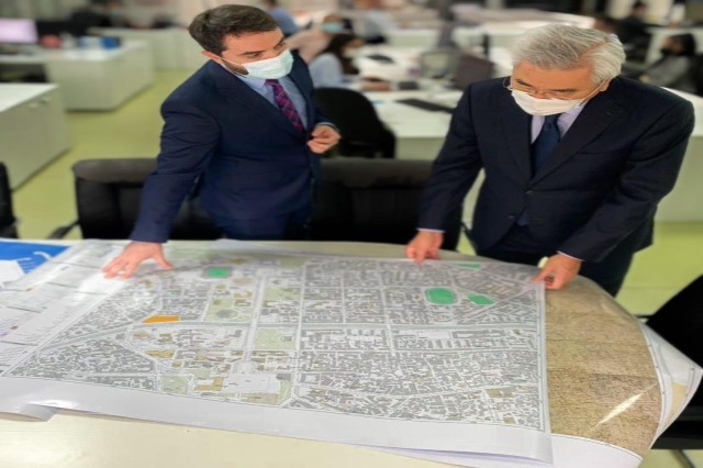
Albania has created for the first time digital topographic maps of contemporary standards, which come in support of sustainable and long-term development of the economic and social sectors of the country.
Since 2017, the Albanian government in cooperation with the Government of Japan, through the Japan International Cooperation Agency (JICA), supports the State Authority for Geospatial Information (ASIG), to implement the Geospatial Information and Sustainable Land Development Project in the Zone Tirana-Durrës ”.
The main objective of the project is to increase social and economic development activities in the area, utilizing large-scale digital topographic maps. The project has also successfully developed the production capacity of topographic maps and the accuracy of the State Geospatial Information Authority (ASIG).
The Closing Conference of the Project as well as the Balkan Regional Conference were held on November 4 and 5, to share the results achieved with stakeholders, government agencies, municipalities, embassies of Japan in the Balkan region, local companies, etc., who are potential users of digitally created topographic maps.
The ceremony took place at the ASIG headquarters in Tirana, attended by the Ambassador of Japan to Albania Takada Mitsuyuki, the Chief Representative of the Balkan Office of JICA, Takeichi Jiro, the General Director of ASIG Lorenc Çala and other interested actors.
“We have successfully crowned an important technical assistance project that Japan has implemented in Albania in the last three years. We have gathered today to share with you the achievements of this important venture, very much hoping that the expertise and knowledge gained from this project as well as its main product, digital topographic maps, will help the Albanian authorities in their daily work, giving them value and facilitation of the processes related to urban planning as well as the social and economic development of the country,” said the Ambassador of Japan in Albania, Takada Mitsuyuki.
He stressed that, “Japan has made significant efforts to promote the construction of quality infrastructure abroad for sustainable development, side by side with domestic partners in developing countries.”
“The project implemented in Albania with ASIG, is the last of a precious necklace with valuable expertise that Japan has contributed to the development of the Western Balkans. “I am especially happy today to see this fact,” said the ambassador.
While director Çala said that “about 80% of the decision-making of Central and Local Government directly affects the territory and the existence of digital topographic maps already helps tremendously in the planning, development and monitoring activities of many institutions in Albania.”
He said that the digital maps were created with the support of the JICA project, which has developed in Japan, long-term and short-term training for a good part of ASIG staff, related to advanced data collection technologies, updating and making the best use of geospatial information.
During the Regional Conference on Geospatial Information, the results of the project were presented to the representatives of the national geospatial information agencies of the Western Balkans Region, who at the same time presented their future plans and expectations for technical assistance from JICA.
JICA is the Agency of the Government of Japan, responsible for the implementation of bilateral assistance through Technical Cooperation, ODA (soft) Loans and Grant Assistance.
/Klara Ruci/






















 RTI
RTI