
 English
 Français
 Deutsch
 Italiano
 Turkish
 Greek
 Serbian
Tropoja unknown caves, adventure potential




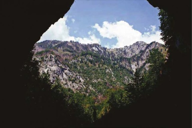
There are so many caves in Albania, with rich potentials for the development of tourism, but they are still dormant, sleepy and unexploited.
Cave visits are a part of natural tourism, or “ecotourism”, that with its continuous development has the potential to attract tourists and diversify the tourist model, increasing its popularity in many countries of the world. Caves are important to the tourism industry because it is a rapidly developing form of tourism in developing countries, where hundreds of caves are visited every year. It can be said that caves have already become a complex natural resource in the tourism market of many countries.
Most of the caves are scattered throughout the territory of the country and yet, most of them have remained in the background without being considered as opportunities for use for adventure tourism.
Tropoja and its caves
The territory of the Municipality of Tropoja lies in the Eastern Albanian Alps and in the Highlands of Gjakova. It consists of limestones, in which the karst process is highly developed; from magmatics in the northeastern part and from terrigenous (clays, sands, conglomerates, sandstones, etc.). The terrain of the municipality is mainly mountainous. It extends from about 170 meters to 2582 meters above sea level (peak in Jezerce), while the average height of the relief of the territory of the municipality reaches 1105 meters above sea level. The relief has major morphological changes, on the basis of which the western and eastern parts are differentiated.
Due to the large spread of soluble calcareous rocks, their large tectonic fragmentation, the rapid neotectonic development of the structural base; suitable climatic and topographical conditions, in the territory of the Municipality of Tropoja, the process of karst (dissolution of limestone rocks) is very developed, which makes the area known for karst caves.
In the territory of the Municipality of Tropoja, there are large stretches of soluble (limestone) formations, where karst caves are formed. Some of them are ranked among the largest caves in Albania and among the largest in the Balkans. These caves are located in the National Park of Valbona: and the Municipal Nature Park Nikaj – Mertur.
Until now, the following karst caves have been discovered in the territory of Tropoja Municipality:
I. In the Valbona National Park
1. Haxhi Cave – It is located on the Dry peak, near the village of Valbona and can be visited along the Bajram Curri – Valbonë – pedestrian route.
2. Ice Cave – It is located near the village of Valbonë and can be visited along the Bajram Curri – Valbonë – path route.
3. Dragobi Cave – It is located near the village of Dragobi and can be visited along Bajram Curri – Dragobi – Valbona – footpath.
4. Black Cave – It is called differently: Qereçi, Bira e Zeze, Blowing Cave. It is located near the village of Qereç Mulaj, Upper Curraj and can be visited along the Bajram Curri – Lekëbibaj – Upper Curraj – path route.
5. The cave of Perr Boshi – It is located on Mount Boshi, about 6-7 hours on foot from the village of Upper Curraj and can be visited along the Bajram Curri – Lekbibaj – Upper Curraj – path route.
6. The cave at the height of 1750 meters – It is located on Iron Mountain(Mali Hekurave), near Lake Ponarë and can be visited along the road Bajram Curri – Ponarë Lake.
7. Shtarë’s Cave – It is located 3.25 kilometers from the village of Vrana Madhe, on the mountain of Shtreza, at an altitude of 1427 meters above sea level and can be visited along the road Bajram Curri – Lekbibaj – Vrana e Madhe – footpath.
8. Cave of Swallows – This is the name given to a well, on the walls of which swallows have built nests. It is visited along Bajram Curri – Lekbibaj – Vrana e Madhe – the footpath to the heights of Kaki mountain.
9. Lonely Cave – This cave is located between Shtara and Swallows caves. It is visited along Bajram Curri – Lekbibaj – Vrana Madhe – footpath to the heights of Kaki mountain.
10. Kakver Cave – It is located near the village of Upperb Curraj, at the eastern foot of the slope of the Kaki mountain. It can be visited on the route Lekbibaj – Vrane Madhe – Lugu Ndarmajës (about 3-4 hours on foot), while from the village of Upper Curraj the path route takes 5-6 hours.
11. Mark Shytan’s cave – It was named after the shepherd who was the first to signal its existence. It is located near Upper Curraj, at the foot of Bosh peak. It is visited along Bajram Curri – Lekbibaj – Upper Curraj footpath to the heights of Mount Boshi.
12. River Cave – It was explored and excavated in 2009 by the Italian speleological group Faentino, but it is still not fully explored. It is visited along Bajram Curri – Lekbibaj – Upper Curraj footpath, about 2 hours.

/k.s/
Të ngjashme
Latest News







Most read










 RTI